
- Users Rating0.0/5 0
- Downloads24
- Updated At2025-01-27
- Publisher
- Operating SystemAndroid
- License TypeFree
Publisher Description
GPS Camera - GeoTag Map -
📸
📸 Try a fantastic GPS Camera with Timestamp! 🌍
GeoTag: Improve Your Photography with the Ultimate GPS Camera App!
GPS camera app with GeoTag. GeoTag enhances every photo with precise GPS photo location data. GeoTag is your go-to solution for comprehensive geo tagging.
✅
GPS Camera Technology:
Our app uses cutting-edge GPS camera technology to embed accurate GPS photo location data directly into your images, ensuring every photo is enriched with precise location information.
✅
GPS Camera Integration:
With GeoTag, you can view your photos on a GPS Camera, providing a visual journey of your photographic trail. It is ideal for tracking your travels or documenting specific locations.
✅
GPS Camera with Timestamp:
Add detailed timestamps and location data to your photos with the GPS camera with time stamp feature. Customize your geostamps to add depth to every shot.
🧭 Find your GPS photo location! 📌
GeoTagging:
Adding a geotag to your photos is simple with GeoTag. Our intuitive interface allows you to geotag photos as you capture them or add geotags to existing images in your gallery.
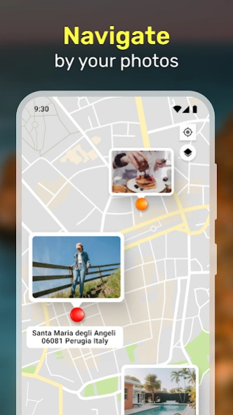
Map GPS Camera Visualization:
The map GPS camera feature lets you see your geotagged photos on various map views.
Geo Map Camera Options:
The geo map camera functionality allows you to view your photos on different map styles, including satellite and standard views, perfect for visualizing your photo locations in detail.
Geotag Photos for Every Scenario:
Whether documenting site-specific data for work or capturing personal moments, our geotag photo app adapts to your needs.
👉
From real estate to agriculture:
GeoTag is the ideal tool for any field requiring precise location data.
👉
Map Photo Location Accessibility:
Easily access and display the map photo location of your images.
👉
Share and Export:
Use GeoTag to share your geotagged photos with friends, family, or colleagues.
👉
Export your images
with geostamps in various formats, including KML, CSV, and XLS files.
🌎 Get a GPS Camera with Time Stamp - Try it! 🗺️
Camera Mode:
Launch the app to enter Camera Mode, where you can capture photos with real-time GPS coordinates, altitude, and accuracy displayed on-screen.
Every image taken is automatically geotagged, ensuring precise location data is embedded in the EXIF metadata.
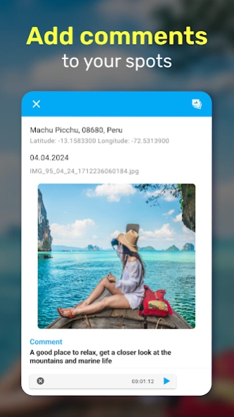
Image Mode:
View your geotagged photos, their coordinates, and their locations on a map. Add geostamps, edit geodata, and add text or voice notes for additional context.
Gallery Mode:
Organize your images by name, creation time, or distance.
📸 Transform your mobile device into a powerful GPS camera with GeoTag! ✨
👉
Agriculture:
Collect and analyze vital geodata for farming applications. Use the map gps camera to document field conditions, crop health, and more.
👉
Urban Planning and Reporting:
Capture and geotag photos of urban issues like fallen trees or parking violations. Use the gps image camera to document and report hazards accurately. The Ultimate Free Geo Camera App.
🌟 Join the GeoTagging Revolution!
✅
GeoTag Photo App:
Enhance every photo with detailed geotags, timestamps, and location data.
✅
Add Geotag Easily
: Use our user-friendly tools to add effortlessly geotags to new or existing photos.
✅
GeoTag Map Camera:
Navigate through your geo-tagged photo collections, discovering patterns and stories hidden in your travels.
✅
GeoTag Photos:
Ensure every image tells a complete story with precise GPS data.
✅
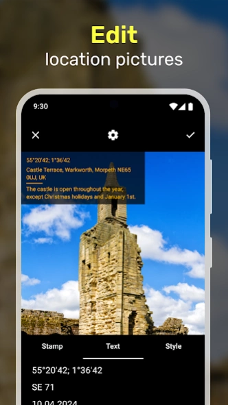
Map Stamp Camera Features:
Customize your geostamps to include dates, times, and specific locations.
✅
Geo Camera App Free:
Start geotagging today at no cost, with robust features rivaling premium apps.
GPS geodata: take geodata, fake, edit or delete GPS exif on smartphone camera!
🗺️ GPS Camera App - GeoTag Map! 📍📸
📸 Try a fantastic GPS Camera with Timestamp! 🌍
GeoTag: Improve Your Photography with the Ultimate GPS Camera App!
GPS camera app with GeoTag. GeoTag enhances every photo with precise GPS photo location data. GeoTag is your go-to solution for comprehensive geo tagging.
✅
GPS Camera Technology:
Our app uses cutting-edge GPS camera technology to embed accurate GPS photo location data directly into your images, ensuring every photo is enriched with precise location information.
✅
GPS Camera Integration:
With GeoTag, you can view your photos on a GPS Camera, providing a visual journey of your photographic trail. It is ideal for tracking your travels or documenting specific locations.
✅
GPS Camera with Timestamp:
Add detailed timestamps and location data to your photos with the GPS camera with time stamp feature. Customize your geostamps to add depth to every shot.
🧭 Find your GPS photo location! 📌
GeoTagging:
Adding a geotag to your photos is simple with GeoTag. Our intuitive interface allows you to geotag photos as you capture them or add geotags to existing images in your gallery.
Map GPS Camera Visualization:
The map GPS camera feature lets you see your geotagged photos on various map views.
Geo Map Camera Options:
The geo map camera functionality allows you to view your photos on different map styles, including satellite and standard views, perfect for visualizing your photo locations in detail.
Geotag Photos for Every Scenario:
Whether documenting site-specific data for work or capturing personal moments, our geotag photo app adapts to your needs.
👉
From real estate to agriculture:
GeoTag is the ideal tool for any field requiring precise location data.
👉
Map Photo Location Accessibility:
Easily access and display the map photo location of your images.
👉
Share and Export:
Use GeoTag to share your geotagged photos with friends, family, or colleagues.
👉
Export your images
with geostamps in various formats, including KML, CSV, and XLS files.
🌎 Get a GPS Camera with Time Stamp - Try it! 🗺️
Camera Mode:
Launch the app to enter Camera Mode, where you can capture photos with real-time GPS coordinates, altitude, and accuracy displayed on-screen.
Every image taken is automatically geotagged, ensuring precise location data is embedded in the EXIF metadata.
Image Mode:
View your geotagged photos, their coordinates, and their locations on a map. Add geostamps, edit geodata, and add text or voice notes for additional context.
Gallery Mode:
Organize your images by name, creation time, or distance.
📸 Transform your mobile device into a powerful GPS camera with GeoTag! ✨
👉
Agriculture:
Collect and analyze vital geodata for farming applications. Use the map gps camera to document field conditions, crop health, and more.
👉
Urban Planning and Reporting:
Capture and geotag photos of urban issues like fallen trees or parking violations. Use the gps image camera to document and report hazards accurately. The Ultimate Free Geo Camera App.
🌟 Join the GeoTagging Revolution!
✅
GeoTag Photo App:
Enhance every photo with detailed geotags, timestamps, and location data.
✅
Add Geotag Easily
: Use our user-friendly tools to add effortlessly geotags to new or existing photos.
✅
GeoTag Map Camera:
Navigate through your geo-tagged photo collections, discovering patterns and stories hidden in your travels.
✅
GeoTag Photos:
Ensure every image tells a complete story with precise GPS data.
✅
Map Stamp Camera Features:
Customize your geostamps to include dates, times, and specific locations.
✅
Geo Camera App Free:
Start geotagging today at no cost, with robust features rivaling premium apps.
About GPS Camera - GeoTag Map
GPS Camera - GeoTag Map is a free app for Android published in the Screen Capture list of apps, part of Graphic Apps.
The company that develops GPS Camera - GeoTag Map is Prometheus Interactive LLC. The latest version released by its developer is 2.1.2.
To install GPS Camera - GeoTag Map on your Android device, just click the green Continue To App button above to start the installation process. The app is listed on our website since 2024-09-26 and was downloaded 24 times. We have already checked if the download link is safe, however for your own protection we recommend that you scan the downloaded app with your antivirus. Your antivirus may detect the GPS Camera - GeoTag Map as malware as malware if the download link to travel.minskguide.geotag is broken.
How to install GPS Camera - GeoTag Map on your Android device:
- Click on the Continue To App button on our website. This will redirect you to Google Play.
- Once the GPS Camera - GeoTag Map is shown in the Google Play listing of your Android device, you can start its download and installation. Tap on the Install button located below the search bar and to the right of the app icon.
- A pop-up window with the permissions required by GPS Camera - GeoTag Map will be shown. Click on Accept to continue the process.
- GPS Camera - GeoTag Map will be downloaded onto your device, displaying a progress. Once the download completes, the installation will start and you'll get a notification after the installation is finished.
Gameplay and screenshots


Version History
Here you can find the changelog of GPS Camera - GeoTag Map since it was posted on our website on 2019-10-25.
The latest version is 2.1.2 and it was updated on Apk-Fort on 27 January, 2025.
See below the changes in each version:
Version 2.1.2
Fixed crashes and bugs
2024-09-26Version 2.1.1
2024-09-26Version 1.4.21
Crashes are fixed
2021-02-01Version 1.4.17
fixed bugs
added Spanish2021-01-13Version 1.4.16
fixed bugs
updated pdf reports2020-12-24Version 1.4.15
Fixed display of the map in the report
Fixed marker rotation on the map
Fixed bugs and crashes2020-12-18Version 1.4.14
This version has implemented for you:
* Flexible stamp settings
* Ability to create a report in KML format
* Bugfix2020-12-05Version 1.4.5
fixed crashes
2020-03-17Version 1.4.4
bug fixed
2020-01-31Version 1.4.1
fixed bugs
2020-01-13
RELATED PROGRAMS
Our Recommendations
Geotag Camera With Location 1.14
FREE ANDROIDCapture and Geotag Your Photos with Precision Using Our GPS Camera App 📸🗺️ ...

Geotag Map Camera Location App 9.0
FREE ANDROIDGeotag Map Camera Location App: Captures and preserves the exact location of every moment. Trying to...
Tagofy - Geotag Map Camera 4.4
FREE ANDROIDTagofy - Geotag GPS Camera: Capture & Relive Every Moment with Precision Tagofy - Geotag GPS...
GPS Photo: With Location & Map 4.0.5
FREE ANDROIDGPS Camera Photo Location - Your Ultimate Geotagging Tool! Capture memories with precision...
Geotag Photos: Camera Location 1.0.8
FREE ANDROIDWelcome to Geotag Photos Pro - your ultimate navigation tool to help you stay on track with pinpoint...
GPS Map Location 1.0.3
FREE IOSNever forget a moment. Timestamp and geotag photos and videos with a GPS Map camera, photo...
Tagofy - Geotag Map Camera 3.1
FREE IOSEnhance your photos with Tagofy - Geotag Map Camera app, by adding latitude & longitude, GPS...
GPS Camera & GPS Earth Maps 1.3.2
FREE ANDROIDGPS Map Camera: Geotag Photos & Location on Pictures 🔍 Capture and tag your moments with...